A Photo Tour of the Alaska Highway, Summer 2008
ALL Photos © K. Dewey, School of Natural Resources, Applied Climate Sciences, UNL.
|
|
|
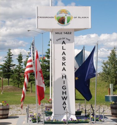
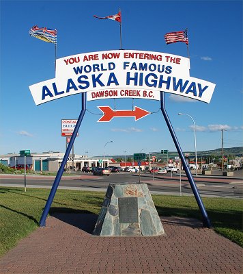
The Alaska Highway begins in Dawson Creek, British Columbia
(BC) and ends 1390 miles to the northwest in Delta Junction, Alaska
(AK), the official end of the highway. The above two photos show
the two monuments marking the start of the highway in Dawson Creek, BC. The highway
continues on as Alaska Highway 2 from Delta Junction to the unofficial
end of the highway in Fairbanks, AK (98 miles northwest of Delta
Junction). The distance from Dawson
Creek, BC to Fairbanks, AK is a total of 1488 miles. Dawson Creek,
BC is approximately 370 miles northwest of Edmonton, Alberta. The map
below shows an overview of the route from Dawson Creek, BC (label "A") to
Delta Junction, AK (label "B").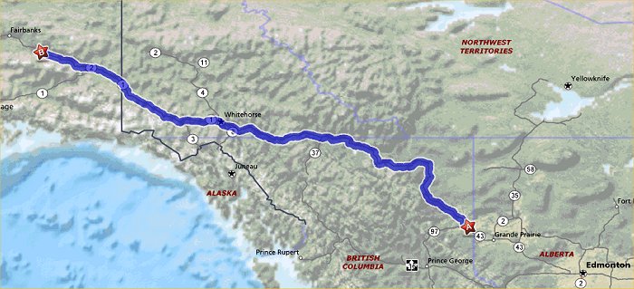 The publication "The Milepost", 2008 Edition, was used as the guidebook for this entire trip. Their motto is "Since 1949, The Bible of North Country Travel". This publication is truly the essential guide to everything you need to know to get the most out of your trip along this historic highway. It includes mile by mile logs of not only the Alaska Highway but numerous other routes as well. It includes information about sightseeing, wildlife viewing, camping & fishing, road conditions, and accommodations as well as many useful helpful hints to get the most out of your traveling in this part of North America. The Milepost is updated annually by their field editors and is available at most book stores that have travel sections. It is also available on-line from Amazon and Barnes and Noble. It is also available via their Internet site: http://milepost.com/. We strongly recommend this publication for anyone planning on travelling to this spectacular region of the world.
LINKS to the Alaska Highway Photo Galleries: 1. Dawson Creek to the Rocky Mountains in Northern British Columbia 2. Rocky Mountains to Muncho Lake, British Columbia 3. Muncho Lake, British Columbia to The "Sign Post Forest", at the Yukon Border 4. Across the Yukon to Whitehorse, Yukon 5. Whitehorse, Yukon to the Alaska Border 6. The Alaska Border to Delta Junction, Alaska (official end of the Alaska Highway) 7. Delta Junction, Alaska to Fairbanks, Alaska (unofficial end of the Alaska Highway) Alaska Highway Trip Summary: Day 1: Lincoln, Nebraska to Grand Forks, North Dakota Day 2: Grand Forks, North Dakota to Brandon, Manitoba Day 3: Brandon, Manitoba to Lloydminster, Alberta Day 4: Lloydminster, Alberta to Dawson Creek, British Columbia (Mile Zero, Alaska Highway) Day 5: Dawson Creek, British Columbia to Muncho Lake, British Columbia Day 6: Muncho Lake, British Columbia to Whitehorse, Yukon Day 7: Whitehorse, Yukon to Delta Junction, Alaska (End of the Alaska Highway). Day 8: Delta Junction, Alaska to Fairbanks, Alaska (Un-official end of the Alaska Highway). |