October 23, 2002
An early taste of Winter in Nebraska

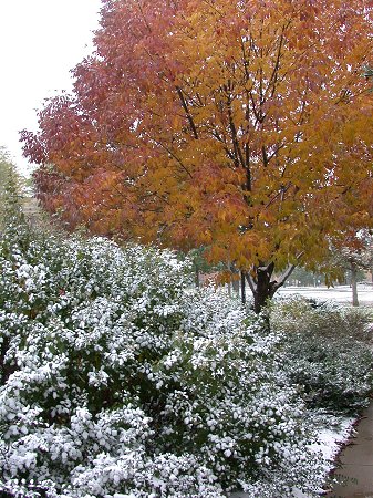
Fresh snow sticks to the green leaves of a bush while a tree
in the background shows its autumn colors of orange and red.
Photographed on east campus of UNL, during the afternoon of October 23, 2002.


October 22, high of 37 F was the coldest high temperture for the date, old record 41 in 1888.

October 23, high of 33 F was the coldest high temperture for the date, old record 40 in 1908.

In 115 years of data keeping, we have never had daytime highs this cold so early in the season!

Link to Radar Loops showing the storm

Link to Photos (October 23)

Link to Photos (October 24)

Link to hourly weather observations
 

OCTOBER 23, 2002 TEMPERATURE AND SNOWFALL TOTALS

LOCATION NEBRASKA :  MAX   MIN   PRECIP. SNOW  SNOW DEPTH 
ALBION            :   27 /  24  / 0.25  / 3.5  /  4 
AUBURN            :   37 /  31  / 0.33  / 0.5  /  T 
DAVID CITY        :   27 /  25  / 0.32  / 2.7  /  3
FORT CALHOUN      :   29 /  26  / 0.36  / 4.7  /  5
GRAND ISLAND      :   30 /  25  / 0.36  / 3.8  /  4
HASTINGS ARPT     :   31 /  25  / 0.27  / 3.1  /  3
LINCOLN           :   33 /  28  / 0.25  / 2.4  /  2 
KEARNEY ARPT      :   30 /  25  / 0.25  / 2.5  /  2
NORFOLK           :   30 /  26  / 0.15  / 2.2  /  2
NORTH PLATTE ARPT :   30 /  23  / 0.49  / 5.7  /  4
OMAHA EPPLEY      :   34 /  29  / 0.17  / 1.6  /  2
OMAHA VALLEY      :   33 /  27  / 0.37  / 3.6  /  4
RAYMOND           :   29 /  26  / 0.22  / 3.5  /  2
SYRACUSE          :   40 /  29  / 0.26  / 3.0  /  3
VALENTINE ARPT    :   26 /  22  / 0.10  / 2.5  /  2

LOCATION IOWA     :  MAX   MIN   PRECIP. SNOW  SNOW DEPTH 
LITTLE SIOUX      :   32 /  26  / 0.22  / 3.5  /  3
OAKLAND           :   39 /  28  / 0.35  / 4.0  /  3

Return to: The Photo Gallery Index Page