 |
 |
|
(this is external to the Nebraska Weather and Climate Web Site) |
|
|
|
|
(this is external to the Nebraska Weather and Climate Web Site) |
|
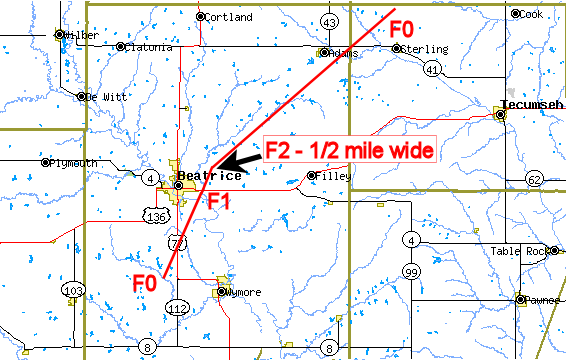
Approximate Track
of the Tornado on April 15th, 2006. Source: NWS Omaha/Valley, NE
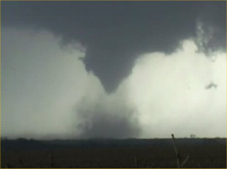
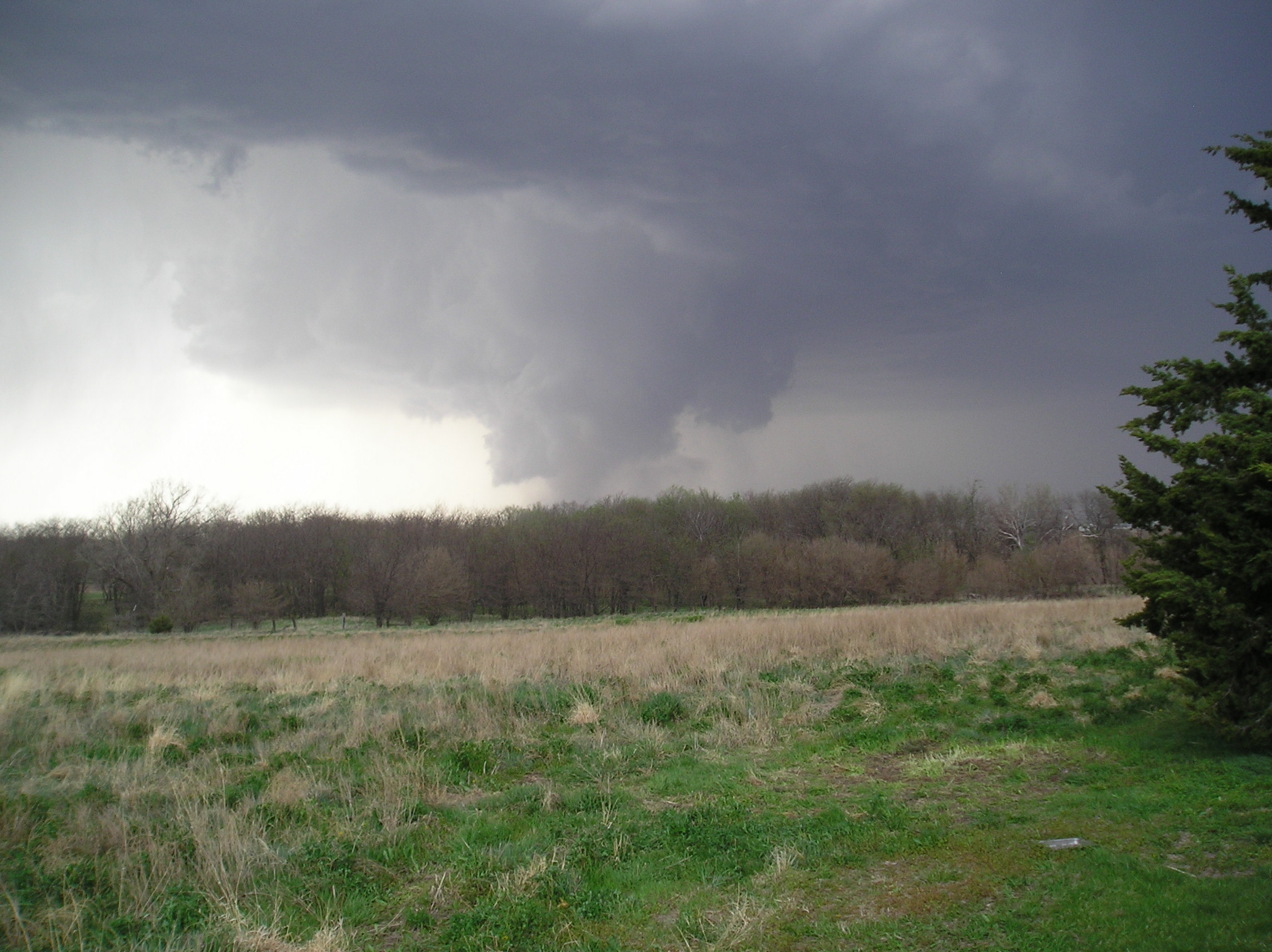
Tornado
near Wymore, Nebraska, April 15, 2006: Photo by Scott Johnson
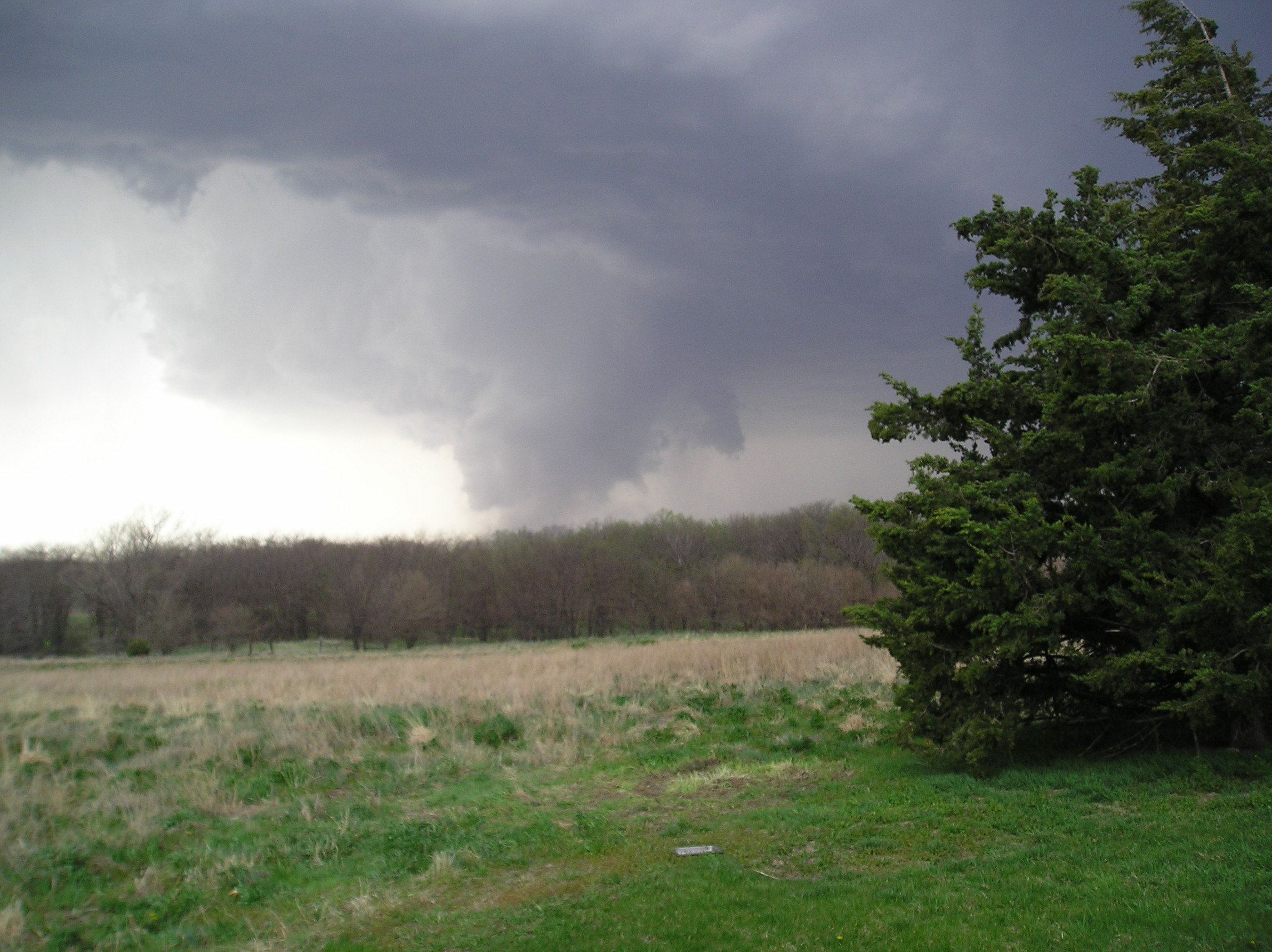
Tornado
near Wymore, Nebraska, April 15, 2006: Photo by Scott Johnson
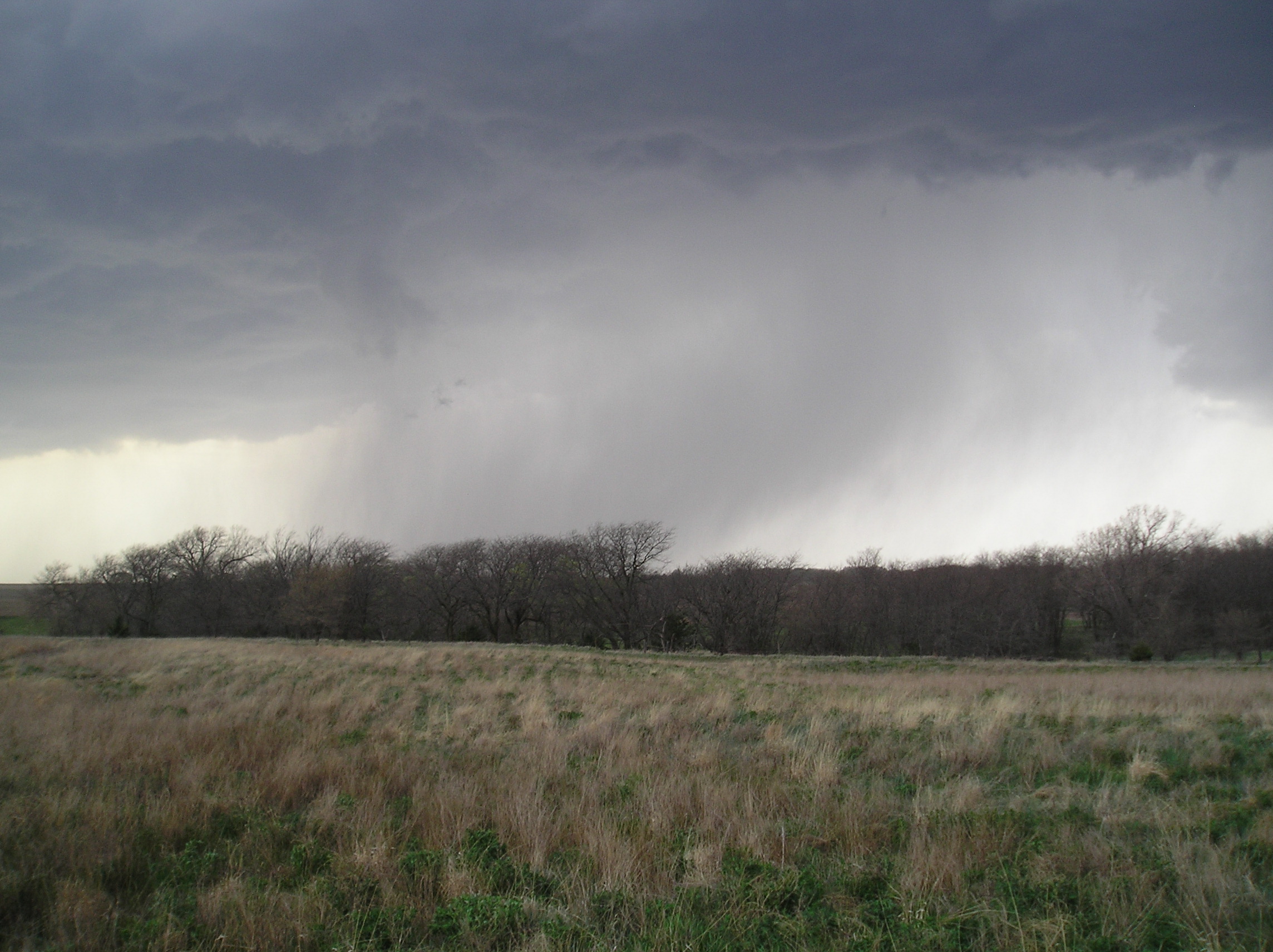
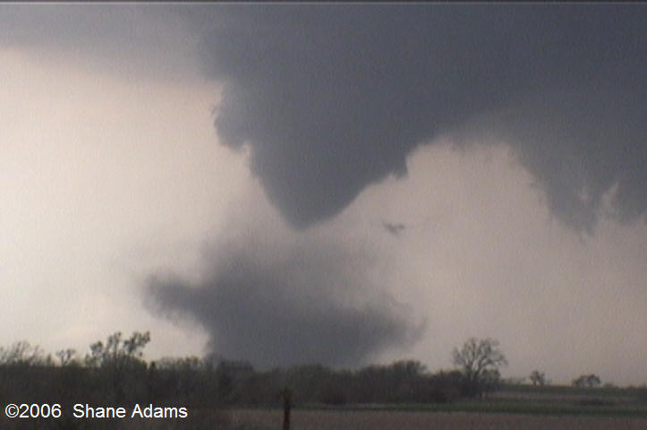
The tornado
near Wymore, Nebraska, April 15, 2006 dissipates with a small funnel remaining:
Photo by Scott Johnson

The tornado
near Wymore, Nebraska, April 15, 2006 dissipates with a small funnel remaining:
Photo by Scott Johnson
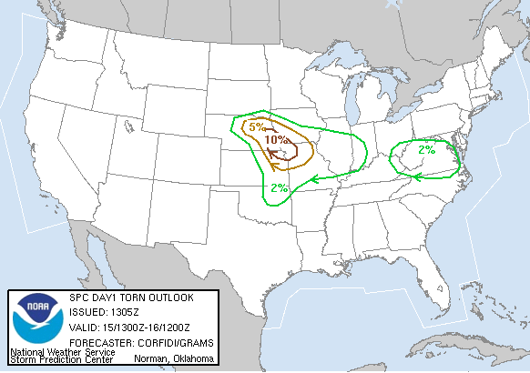
Storm Prediction
Center tornado probability forecast for April 15, 2006.
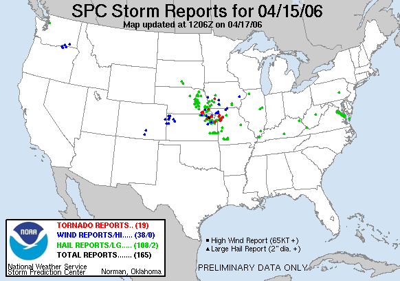
Storm reports
for April 15, 2006.
Note how
the tornadoes occurred right inside the area of highest forecast probability.
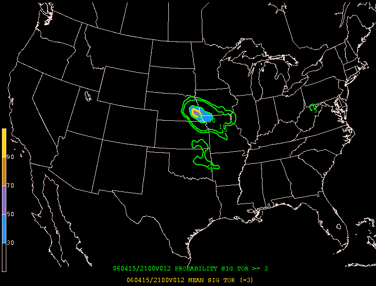
probability
of a "significant" tornado as forecast by the Storm Prediction Center in
the morning of April 15, 2006.
The large
Gage County tornado occurred right in the middle of the highest forecast
probability.
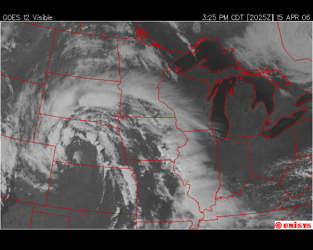
Satellite
Image, April 15, 2006, 3:25 PM CDST.
The thunderstorm
that spawned the Gage County tornado is forming at the Nebraska/Kansas
border.

Satellite
Image, April 15, 2006, 4:25 PM CDST.
The Gage
COunty tornado producing thunderstorm is one of several severe thunderstorms
that arc
from north central Nebraska through southeast Nebraska.

Satellite
Image, April 15, 2006, 5:25 PM CDST
| Picking
up the pieces - Beatrice Daily Sun Newspaper
By Harold Campbell/Daily Sun staff
writer
Family members and neighbors traveled from far and wide to help clean up the destruction left by a tornado that struck Gage and Johnson counties Saturday afternoon. �We're just extremely pleased to have such wonderful friends and family,� Annette Wiese, 6532 E. Sargent Road, said Sunday afternoon. �People have been giving out of the goodness of their heart.� Wiese and her husband, Gary, lost their two chicken houses, each 76 feet wide and 432 feet long and holding 86,000 broilers earlier in the week, and sustained other property damage in Saturday's storm. Mrs. Wiese said fortunately the broilers had been shipped to MBA Poultry in Tecumseh Thursday at 48 days old, about four days before they are usually shipped. �If they wouldn't have been shipped early we would've had about 80,000 chickens wandering around out here,� Gary Wiese said. The Wiese family said more than 150 people arrived to help Saturday night with another 100 or more coming Sunday. In addition to family and friends, equipment and volunteers came from a number of local and area construction firms, Mrs. Wiese said. �I've been mainly here to tell people what they can do to help,� Wiese said. Jeff Argo, who lives about two
miles north of the Wieses, was one of the many who came to help with the
cleanup.
�Everybody around here knows everybody else,� he said. �They're good neighbors.� Gage County Emergency Management Director Mark Meints said no official damage figure was available, but he estimated the tornado destroyed at least $1 million in property Saturday. Fortunately, he said, no injuries or deaths were reported. Meints said 73 homes were affected by the tornado - one was destroyed, two received major damage and the rest received repairable damage. ooo About a mile from the Wiese residence, the Gil and Judy Buhr farm at 5109 E. Hoyt Road received extensive damage to its two hog sheds and other outbuildings and to the farm office and garage. More than 1,000 hogs from the Buhr farm were taken to the Beatrice 77 Livestock Sale Barn after the storm hit. Mrs. Buhr said offers for assistance started coming as soon as the tornado left. �We've had some wonderful help from family and friends,� she said. �I'm sure they know we would do the same thing for them.� Jim and Shirley McPheron, 1552 E. Lilac Road, also reported they were overrun with help from friends and family following the tornado, which leveled a number of outbuildings, damaged their house, blew out the rear windshields to a number of their vehicles and wrapped a windmill across the top of their garage. �A lot of people stopped by and helped,� Jim McPheron said. �It was just amazing.� ooo Meints said Saturday's tornado was first spotted about 4:28 p.m. Saturday on the ground west of the intersection of Nebraska Highway 112 and U.S. Highway 77 about seven miles west of the Wymore-Blue Springs area. The tornado traveled to about two and a half miles east of Beatrice and then continued northeast to just north of Sterling, where property and power line damage were also reported. Meints said the tornado finally lifted about one mile south of the Johnson-Otoe county line after being on the ground for 34 miles. In contrast, the Hallam tornado, which Meints said set a record for staying on the ground for the longest time of any tornado, remained on the ground for 58 miles. �Saturday's tornado was on the ground for an extended time,� he said. According to a statement issued Sunday afternoon by the National Weather Service Valley office, the tornado reached its maximum strength of F2 on the Fujita scale -- with winds between 113 and 157 mph - about five miles northeast of Beatrice. The NWS also reported the tornado reached a maximum width of one-half mile wide. The Fujita scale ranks tornadoes based on wind speed and the damage they can cause. A strength of F2 on the Fujita scale means the tornado is capable of tearing roofs from frame houses, demolishing mobile homes, overturning train cars, lifting cars off the ground and snapping or uprooting large trees, the NWS said. Meints said David Anderson, Gage County Board of Supervisors chairman, signed a decree Saturday evening declaring a natural disaster, which was forwarded to the governor's office. Meints said the decree was signed mainly in case state assistance such as calling in the National Guard was needed. �At that time, we didn't know exactly what we would need,� he said. Assisting in the storm effort Saturday were rural fire departments from Odell, Barneston, Wymore, Blue Springs, Beatrice rural and city, Filley, Pickrell, Cortland, Clatonia and Adams. Meints said rural fire departments helped in handling propane tank leaks and other duties. Aid also came from Diller, Jefferson County Emergency Management, the Gage County Sheriff's Office and Gage County Highway Department. Meints said the Salvation Army and Red Cross were also called in to provide assistance. Red Cross disaster teams were assisting Sunday in performing damage assessments in the area. Although damage was extensive to homes and outbuildings in the county, Meints said damage to county roads was still uncertain. However, barricades were placed at South 51st Road and U.S. Highway 136 because of heavy debris on the roadway, he said. Meints said his office was beginning to coordinate with volunteer groups interested in helping with cleanup efforts. Groups interested in helping with storm clean-up should call the emergency management office at 402-223-1305. He also said he would meet with Beatrice Area Solid Waste Agency officials Monday to determine what can be done about disposing of debris left from the storm. ooo Those who suffered property damage from the storm said Sunday they were most thankful the tornado caused no injuries or deaths. Shirley McPheron said the satellite television went out Saturday afternoon and when she turned on the radio she heard a report of a tornado about 10 miles south of Beatrice. A short time later, however, strong winds broke out a large window in the family's living room and she and her husband headed for the basement. A few minutes later, they emerged and saw the extensive damage. Not only were windows blown out, the roof to their house was damaged, trees were uprooted and outbuildings were destroyed. �Nothing was left untouched,� she said. Fortunately, she said, the family's 2-year-old golden retriever Jesse and their goats survived the storm without injury. �I was about to bring Jesse inside, but that was when the windows blew out and I thought it was best to get to the basement right then,� she said. However, when the storm passed and she and her husband started to examine the damage, they found Jesse curled up inside a window well with her face next to the ground. �I think she was pretty scared,� Mrs. McPheron said. McPheron said he also found the family's goats were also safe. �They were scared to death, but they were OK,� he said. Chuck Benash, 2954 E. U.S. Highway 136, had another animal survival story. Although the tornado uprooted about 10 large trees and destroyed several outbuildings on his property - including his auto repair business, where a tree landed on a Ford Taurus - and his barn, he said the six horses inside the barn managed to find a safe place to hide and were unharmed. �It was raining so hard I couldn't see, but when it stopped the first thing I did was go check on the horses,� he said. �I don't know how it happened, but they were all right.� Miraculously, he said, his house sustained no damage and two lawn chairs sitting outside were not even moved. �Now, we're just going to get things cleaned up,� he said. At the Wiese house, Annette Wiese said the family stayed up until 1 a.m. Sunday cleaning up debris and then were up again about 5:30 a.m. Sunday. Along with the other damage to the property, a weather station Gary Wiese received as a birthday present and was sitting on the roof blew away. The last recorded wind speed on the station was 109 mph. At the Buhr farm, in addition to the farm buildings, the house received damage to the siding and some glass was blown out. �We're mighty fortunate someone
didn't get hurt,� Judy Buhr said
|
| F2 Tornado in Gage County 4/15/06
PUBLIC INFORMATION STATEMENT
...TORNADO UP TO F2 STRENGTH MOVES
THROUGH GAGE AND JOHNSON COUNTIES
A STORM SURVEY WAS CONDUCTED TODAY
IN GAGE AND JOHNSON COUNTIES FOR
THE TORNADO REACHED ITS MAXIMUM
STRENGTH...F2...ABOUT 5 MILES EAST
TORNADOES ARE RATED BASED ON THE
DAMAGE THEY CAUSE. F2 STRENGTH ON
TORNADO INTENSITY FROM THE FUJITA SCALE STRENGTH
ESTIMATED WIND SPEEDS
|
Click Here for the Lincoln Journal Star News Report - external to this site
|
PRELIMINARY LOCAL STORM REPORT...SUMMARY
..TIME... ...EVENT...
...CITY LOCATION... ...LAT.LON...
0408 PM
HAIL
5 S FRIEND
40.58N 97.28W
0422 PM
HAIL
UTICA
40.90N 97.35W
WINDS OF 55 MILES AN HOUR 0430 PM
HAIL
3 SE ALBION
41.66N 97.96W
0433 PM
TORNADO 10 SW BEATRICE
40.17N 96.88W
DEBRIS OBSERVED 0436 PM
TORNADO 5 S BEATRICE
40.20N 96.75W
0439 PM
HAIL
2 N RISING CITY 41.23N
97.30W
0452 PM
TORNADO 4 E BEATRICE
40.27N 96.67W
SIGNIFICANT DAMAGE REPORTED 0458 PM
HAIL
PLATTE CENTER
41.54N 97.49W
0458 PM
HAIL
1 S DUNCAN
41.35N 97.49W
0500 PM
HAIL
NEWMAN GROVE
41.75N 97.78W
0523 PM
HAIL
PALMYRA
40.71N 96.39W
0532 PM
HAIL
OMAHA
41.26N 96.01W
24TH AND VINTON ST 0535 PM
HAIL
BATTLE CREEK
42.00N 97.60W
0536 PM
TSTM WND DMG STERLING
40.46N 96.38W
POWER LINES DOWN AND OTHER PROPERTY DAMAGE 0540 PM
HAIL
STEINAUER
40.21N 96.23W
0543 PM
HAIL
3 NE EAGLE
40.85N 96.39W
0545 PM
HAIL
UNADILLA
40.68N 96.27W
0552 PM
HAIL
PIERCE
42.20N 97.53W
0554 PM
HAIL
1 E NORFOLK
42.03N 97.40W
0555 PM
HAIL
AVOCA
40.80N 96.12W
0555 PM
HAIL
ELK CREEK
40.29N 96.13W
0600 PM
HAIL
3 E JOHNSON
40.41N 95.94W
0625 PM
HAIL
1 SW JULIAN
40.51N 95.88W
0625 PM
HAIL
6 NW WISNER
42.05N 97.00W
0637 PM
TORNADO 2 N JULIAN
40.55N 95.87W
ALONG HIGHWAY 75...SOME TREE DAMAGE NOTED. 0650 PM
HAIL
5 W UNDERWOOD
41.39N 95.78W
0708 PM
HAIL
TABOR
40.89N 95.67W
0710 PM
TSTM WND GST 2 NE LITTLE SIOUX
41.83N 96.00W
DAMAGE TO ROOF AND TREE LIMBS DOWN, LATE REPORT. 0715 PM
HAIL
2 W HASTINGS
41.02N 95.53W
0752 PM
HAIL
6 WSW COLERIDGE 42.47N
97.31W
0817 PM
FUNNEL CLOUD ELK HORN
41.59N 95.06W
0925 PM
HEAVY RAIN 6 NW FORDYCE
42.76N 97.45W
WATER OVER HIGHWAY 81, EIGHT MILES SOUTH OF YANKTON
|
Return to: The Photo Gallery Index Page