"Top of the World Highway", Alaska to The Yukon, Canada - - July 2008
| This spectacular
highway runs from the Alaska/Yukon border to Dawson City, Yukon. This photo tour begins with the Taylor highway (Alaska Highway 5) at Tetlin Junction, Alaska (which is just east of Tok, Alaska and on the Alaska Highway, up to the Yukon border, where it joins the "Top of the World Highway". The Taylor Highway is 105 miles long ending at the Yukon border crossing and the "Top of the World" Highway, is 65 miles long ending in Dawson City, Yukon. |
ALL Photos © K. Dewey, School of Natural Resources, Applied Climate Sciences,
UNL.
|
|
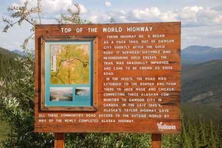
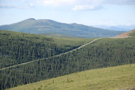
| Click HERE for a larger easier to read version of this sign | Click HERE to see a much larger version of this image |
| The publication "The Milepost", 2008 Edition, was used as
the guidebook for this entire trip. Their motto is "Since 1949, The
Bible of North Country Travel". This publication is truly the essential
guide to everything you need to know to get the most out of your trip
along this historic highway. It includes mile by mile logs of not only
the Alaska Highway but numerous other routes as well. It includes
information about sightseeing, wildlife viewing, camping & fishing, road
conditions, and accommodations as well as many useful helpful hints to
get the most out of your traveling in this part of North America. The
Milepost is updated annually by their field editors and is available at
most book stores that have travel sections. It is also available
on-line from Amazon and Barnes and Noble. It is also available via
their Internet site: http://milepost.com/.
We strongly recommend this publication for anyone planning on travelling
to this spectacular region of the world. |
| PHOTO LINKS: |
| Top of the World Photo Set One |
| Top of the World Photo Set Two |